Recent progress has been made by the NWS in disseminating weather data to emergency
managers. Since the early 1990's, the Forecast Systems Laboratory (FSL), through
their Dissemination Project (Jeseroga et al. 1998) based in the Boulder/Denver area
of central Colorado, has laid a foundation to improve this situation. Much of their work
will be incorporated into a component of the Advanced Weather Interactive Processing
System (AWIPS) known as the Local Data Acquisition and Dissemination system (LDAD;
Jeseroga et al. 1998). Yet, the concern noted in the following quote from the National
Academy of Sciences (1980) still seems true today: Based upon a perceived national problem of local access to perishable environmental
information and upon experiences and end-user feedback gained through operating the
Oklahoma Mesonetwork and an associated educational outreach program for K-12 schools,
OCS received federal funding to begin the project known as OK-FIRST. The source of
these funds was the Telecommunications Information and Infrastructure Assistance
Program (TIIAP), an agency within the U.S. Department of Commerce that provides grants
to improve the application of telecommunications technology by sectors of society that
are under-served
by our nation's telecommunications infrastructure. TIIAP allows these funds to be
used for both hardware and end-user support. In September 1996, OCS received the
largest public-safety grant that TIIAP awarded that year. This paper describes the
project, presents preliminary evaluation results, and discusses the early impact on project
participants through their use of products provided by OK-FIRST. OCS/Mesonet also supported some public safety agencies in a limited manner. First,
several emergency managers and fire departments were regular Mesonet subscribers.
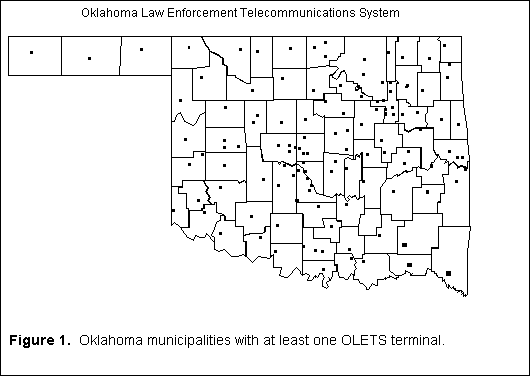
In addition, the Mesonet was permitted to utilize the Oklahoma Law Enforcement Telecommunications System (OLETS) to transmit raw observations from 114 remote weather stations
to the central processing facility at OCS. In return, a facility was developed to
automatically create ten textual tables of Mesonet observations grouped by geographical region. These tables were sent via OLETS from the Mesonet processing computers
to reside on the OLETS message-switch computer in Oklahoma City. In turn, a dispatcher
at any of the 160+ OLETS agencies (police, sheriff, highway patrol; Fig. 1) could
obtain the latest Mesonet observations by simply typing an
appropriate command on their OLETS terminal. For example, typing "WXCTR" would fetch
the central Oklahoma Mesonet observations. However, the OLETS message switch was
not designed to store large amounts of data. Rather, its purpose was simply to route
messages from one OLETS agency to another (e.g., drivers license records and criminal
rap sheets). As a result, this method for OLETS agencies to obtain Mesonet data
could not be expanded 1. The NWS modernization began, during the past decade, with the implementation of its
WSR-88D (NEXRAD) network. Previous NWS policy on the dissemination of radar data
allowed anyone to access radar data if they placed appropriate hardware at a local
NWS office to interface with the radar. However, because this strategy contributed to maintenance
problems, a different approach was implemented for disseminating NEXRAD data to non-NWS users
. Four private vendors were given the exclusive right to distribute NEXRAD data through
NIDS -- the NEXRAD Information Dissemination Service (Klazura and Imy 1993). However,
many small agencies, who previously had used radar data, appear to have been "priced out of the market". A primary reason for this situation was that a prohibitively
expensive infrastructure was necessary (both telecommunications equipment and staffing)
for each NIDS vendor to acquire six-minute data from each radar, serve a myriad of small and local agencies, and provide end-user support.
Two NIDS vendors, however, recognized the success of OCS in using low cost and reliable
telecommunications to distribute weather data to local communities in Oklahoma.
In early 1995, these two vendors independently approached OCS with an offer to redistribute
NIDS data to state and local government agencies. Based upon cost and other considerations,
OCS chose to pursue the offer presented by Unisys Weather Information Services of
Kennett Square, PA.
While the NIDS vendors began to sign reseller agreements with other private firms,
OCS and Unisys signed in early 1997 what, to our knowledge, is the only NIDS redistribution
contract with a state agency.
During the past five years, most Mesonet customers received Mesonet access via a dial-up
bulletin board system (BBS). For many schools and other government agencies outside
the Oklahoma City area, several 1-800 lines were established so that the Mesonet
could bear the long distance charges instead of local agencies -- many of whom could
not afford the telecommunications costs. However, this strategy limited the growth
that could be sustained, because telecommunications costs became increasingly expensive
with each additional rural user. Fortunately, the past several years witnessed the
incredibly rapid arrival of the Internet into local communities, resulting in a low-cost
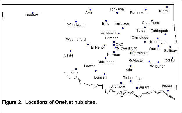
alternative to 1-800 telephone lines. For example, the State of Oklahoma established a statewide telecommunications network (called OneNet) as a conduit for state agencies
and for common and higher educational institutions to access the Internet and to
telecommunicate within the state. OneNet installed 44 hub sites primarily at state
and regional colleges and universities and vo-tech centers (Fig. 2). Each hub site
has a modem pool for local dial-up Internet access, but additional capabilities exist
for high-bandwidth activities (e.g., full-motion video). OneNet also permits local
communities not chosen as hub sites to have dedicated OneNet connections through the
lease of T-1 or higher-speed transmission lines. Because OneNet is the Internet
provider for OCS, any agency connected to OneNet could receive our data in an easy
and effective manner without competing for bandwidth used by the private sector.
With a mature infrastructure in place, the stage was set for OCS to disseminate information
from the modernized NWS. All that was needed were funds to train local officials
on the use of the new data and to provide computers to those agencies whose budgets prohibit them from acquiring adequate visualization and telecommunications technology.
3. THE OK-FIRST TRAINING WORKSHOPS
The project also recognized that many public safety agencies had been successful and
progressive in obtaining funds to update their own computer equipment. Thus, additional
"non-subsidized" participants, who already had Internet access plus adequate computer equipment and system software (e.g., a Windows 95, Windows NT, or a Power Macintosh
system), would be permitted to attend the training workshops at their expense. These
agencies would receive identical training, software and data access as did the subsidized participants.
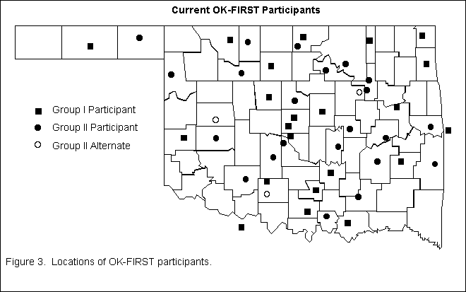
Over 100 applications were received from agencies desiring to participate in the first
classes of OK-FIRST (June and October of 1997). Twenty-two participants and several
alternates were selected (Fig. 3) for each of the first two classes. A requirement for geographic diversity was enforced because one goal of TIIAP is to promote the
use of the nation's telecommunications infrastructure in under-served
(hence rural) sections of the population. Even so, some non-subsidized participants
were permitted to be from urban areas.
The first training workshop consisted of three days of computer training, starting
with basic information about the computer and its operating system. The next topic
was the Internet and how to access OK-FIRST web pages. This included learning to
use "plug-in" software developed by OCS to interactively display Mesonet data and NIDS images
(Wolfinbarger et al. 1998a & b) using web browsers. Because OK-FIRST is a peer-
and decision-support system, conferencing software allows participants to share information and to foster communication among the participants and staff. This software
(FirstClassTM) is identical to the software that drives the BBS described by McPherson and Crawford
(1996). Participants were taught and encouraged to upload OK-FIRST products to the
Mesonet BBS when they had interpretation questions. Throughout the computer training workshop, a wide range of computer skills was exhibited by participants. On occasions,
it was difficult to keep the interest of more advanced students while not overwhelming
more novice users. A week-long data-interpretation workshop was held ten days later to allow participants
time to practice accessing environmental data using the OK-FIRST
system. Two relatively intense days included lectures and laboratory exercises on
severe weather, fire weather, and flash and river flooding. During the fourth day
of the June workshop, a cluster of thunderstorms formed north of Oklahoma City.
These storms and their outflow boundaries moved southward during the next several hours. This
"target of opportunity" was used to teach real-time interpretation skills in a more
relaxed classroom environment. The approach seemed to be of great interest to participants as they learned to apply concepts discussed in previous days of lecture and
laboratory exercises. The last day of the workshop consisted of a final laboratory
exercise, a post-workshop evaluation, and a graduation ceremony.
4. THE OK-FIRST DATA SUITE
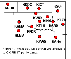
Real-time dissemination of Mesonet and NIDS data (Fig. 4; Morris 1998) was accomplished
by delivering "raw" data to participant computers and requiring the client machines
to decode and display the data using our "plug-in" software. This strategy reduces server overhead and makes data-sharing much more efficient, primarily because Mesonet
and, especially, NIDS data do not have to be preprocessed into the standard image
formats (like GIF or JPEG) that are required for viewing in a web browser. Preprocessing becomes a critical issue when twenty or more NIDS products from 14 radars need
to be disseminated quickly. The raw "unaltered" NIDS files (in the NEXRAD archive
format known as Level III or Level IV) obtained directly from Unisys are small in
size compared to a corresponding GIF image. Both download time and the time between product
updates are minimized. Typically, NIDS images are available to OK-FIRST participants
within 30 seconds of the time the product is created by the radar. In addition,
the web pages that contain NIDS and Mesonet data are designed to refresh themselves automatically
every 6 and 15 minutes, respectively, to ensure users are viewing the most current
information. An additional benefit of this processing scheme arises from the fact that server hardware
and software are completely "off the shelf". Any NIDS subscriber with access to
files in a Level III format, including academic institutions, private companies,
and government agencies, can use the OCS plug-in software to view NEXRAD data. For example,
the initial design of the new radar network did not provide "easy" access for the National Centers for Environmental
Prediction (NWS agencies) to obtain NEXRAD data. Instead, they were provided dial-in
access to any WSR-88D. However, because this approach did not provide an ability
to display mosaic images or a "point-and-click" interface,several National Centers
subscribe to a data-feed from NIDS to provide a real-time, central database of WSR-88D
data. Because the NWS already owns satellite-ingest equipment, they would only need
to use an off-the-shelf web server and the OK-FIRST plug-in software to obtain "point-and-click"
access to any of the NIDS products from any radar.
5. AN EARLY EVALUATION OF OK-FIRST
The Institute for Public Affairs at the University of Oklahoma is providing an independent
assessment of OK-FIRST and its two distinct components by: (1) gauging the degree
to which each round of training in OK-FIRST prepared participants to use products
being disbursed; and (2) examining the usefulness of those products to public safety
officials trained in OK-FIRST. In addition, they are documenting the processes used
in OK-FIRST to provide an ability to replicate the program. Various aspects of the
evaluation are conducted through surveys of computer experience, a series of tests before
and after each
training workshop, focus-group discussions with participants after they finish the
training sessions, and follow-up surveys of participants not at the focus groups. In a survey of participants from the June workshops, twenty-two respondents were asked
to explain any limitations found in the sources of information they had used previously.
Fourteen of the participants reported that a lack of real-time data
(or timeliness) was the biggest limitation to information from past years. Five
participants said the lack of access
to radar data was the biggest limitation. Two respondents reported that a lack of training and support
for interpreting weather information had been a significant limitation as well. Evaluations before and after the computer training workshops indicated that participants
who were near or just below the average on the pretest were the most likely to show
substantial improvement on the post-test. Although many participants with pretest scores in the middle ranges improved as a result of the course, those with scores
near the top and bottom did not. Evaluation results from the data-interpretation workshops indicate that participants
did learn to better identify weather events from NIDS data. On the whole, it seems
that the OK-FIRST data interpretation workshop was a success. A significant improvement of scores was noted in many of the areas listed by OK-FIRST staff as important
objectives. Particularly impressive were the improvements seen in the interpretation
of radar data for various purposes. The primary area of low performance was in the
use of Mesonet data. It seems that participants left without a significantly improved
understanding of Mesonet data and its interpretation.
6. WHAT THE PARTICIPANTS SAY
To help assess the impact of OK-FIRST in modifying the standard operating procedures
at participating agencies, the initial 22 graduates of OK-FIRST were polled 3 months
following their June training. Questions asked of each graduate included: "How has
OK-FIRST impacted your operations?" The statements below reflect their sentiment.
7. SUMMARY
OK-FIRST is an initiative of OCS to serve public safety agencies in Oklahoma as a
conduit to environmental information produced by the modernized NWS. The program
is in response to a perceived national problem that local agencies lack access to
and training in the use of important new data streams. OK-FIRST took its first steps with the Unisys Weather Information Services, who partnered
with OCS to make possible a cost-effective redistribution of NEXRAD data. The U.S.
Department of Commerce provided critical funding while the State of Oklahoma became an Internet Service Provider through its new, state-of-the-art OneNet system.
With these building blocks in place and based upon successes with and experience
in implementing the Oklahoma Mesonet and its educational outreach initiative (EARTHSTORM),
OK-FIRST began in earnest with its first two classes of participants (44 participants
to date). The early results have been extremely favorable. Many public safety officials already
consider OK-FIRST to be "by far the best tool to come along in many years to assist
in the monitoring of weather". Even the NWS Office in Tulsa considers OK-FIRST to
be "a first-rate program that has already benefited the NWS and the state."
8. REFERENCES
Brock, F.V., K.C. Crawford, R.L. Elliott, G.W. Cuperus, S.J. Stadler, H.L. Johnson,
and M.D. Eilts, 1995: The Oklahoma Mesonet: a technical overview. J. Atmos. Oceanic. Technol.
,
12
, 5-19.
"For many years, the National Weather Service ... operated on the assumption that
if they produced a good product, someone would come to get it and use it. ... Users
are currently left largely to their own devices in determining what is available
and how to use it; many are unaware of the information available."
2. HISTORY OF A UNIQUE OPPORTUNITY
In 1978, the Oklahoma Legislature created OCS with a mandate to "acquire, archive,
process and disseminate, in the most cost-effective way possible, all climate and
weather information which is or could be of value to policy and decision makers in
the state." A decade later, plans were formulated for OCS to be a major player in the development
and implementation of the Oklahoma Mesonetwork (Brock et al. 1995). The process
of obtaining stable funding for the operation of the Mesonet involved establishing
an extensive support system, whereby users could obtain Mesonet data, software, and
derived products to analyze at their convenience. The initial OCS foray into end-user
support was the EARTHSTORM Project (McPherson and Crawford 1996) whereby some 50+
public and private schools in Oklahoma access Mesonet data, using computers received
on an extended loan and extensive training in the actual use of Mesonet data in the classroom
.
The initial funding of OK-FIRST permitted the selection of 32 fully-funded, or "subsidized"
participants drawn from three public-safety groups (police, fire and emergency management).
Each participant would receive subsidized access to Mesonet data, the NIDS data stream, NWS products, and related sources of information -- all delivered
via the World Wide Web. Each subsidized participant also would receive a Pentium-class
personal computer on an extended loan and all necessary software required to display
the data. If a participant lacked access to the Internet, OK-FIRST would arrange for
access to OneNet if the rural agency was within the local calling-area of a OneNet
hub site (Fig. 2). In exchange, participants would agree to participate in two mandatory training workshops in Norman. If participant performance was deemed unsatisfactory
by the project staff, then OCS would reclaim the computer and loan it to another
agency.
From Ardmore/Carter County Emergency Management:
"OK-FIRST is by far the best tool to come along in many years to assist this agency
in the monitoring of weather. ... the system has given us almost real-time [radar]
observations, from as little as 1 minute to a maximum of 10 minutes between refreshed
data. ... use the system daily, obtaining weather information which we use in answering
questions from public and governmental agencies. Typical subjects are expected rainfall,
heat index, wind speed and direction, wind chill, and, most importantly, severe weather forecasts. The typical dissemination is to travelers, contractors, fire departments,
police agencies, organizers of outdoor activities, farmers, and industry."
From Durant/Bryan County Emergency Management:
"With OK-FIRST as our partner, we have developed the most improved warning system
that Bryan County has ever experienced. We do believe OK-FIRST will decrease spotter
deployment time and reduce the hazards associated with a storm spotter's field service. The precipitation products from OK-FIRST are particularly useful. Bryan County's
number one hazard is flooding. If we know that heavy rainfall has occurred up-stream,
and that more is expected, we can give advance warning to those people in flood-prone areas and/or close off roads subject to flooding."
From Oklahoma County Emergency Management:
"... an excellent resource to use on our laptop computer for monitoring weather activity
from home
before it is necessary to activate the Emergency Operations Center or our volunteer
storm spotters. ... [We] intend to utilize the program for on-site weather information
once we get into the grass and wildfire season in support of the fire departments
in Oklahoma County."
From Garfield County Emergency Management:
"... having OK-FIRST information and the additional access to other NEXRAD sites,
we monitored our weather in Garfield County via the Wichita and Twin Lakes NEXRAD
sites. It impressed our superiors because we had double-screen viewing and about
5-9 seconds between products needed by our weather team."
From Wilburton-Latimer County Emergency Management:
"On June 16, ... lightning struck our local weather radar and cable TV was knocked
off the air. Without our local radar or commercial television, the EOC normally
would have been 'blind'. OK-FIRST was then the only source of weather information.
... We soon realized that this program gave us all of the information we needed and more.
In addition to protecting Latimer County that evening, we also shared OK-FIRST data
with surrounding cities and counties, such as Haskell County, LeFlore County, McAlester, Hartshorne, Heavener and Talihina."
From Beckham County Emergency Management:
"... use the OK-FIRST program to track rainfall totals across the county, to help
in advising the county commissioners as to total amounts of rainfall in each of their
districts ... gives them an idea of where road damage and bridge damage may have
occurred ... ."
From City of Moore Emergency Management:
"The benefit 'so far' has been in allowing us prior knowledge that we were going
to 'dodge the bullet'. This has kept us from needlessly activating volunteer and
overtime assets. Without the information, we either would have activated the assets,
at a cost to the City, or would have been sweating the decision 'Do I activate or do I hope
that we don't get hit?'. ... We anticipate that OK-FIRST will have an even greater
benefit this winter, with better information to assist our road sanding/clearing
operations, in the late winter/early spring during the grass fire season, and then again
in the spring with the onset of the severe thunderstorm season."
From Muskogee City Emergency Management:
"... used it for heat-index information to issue advisories so that the citizens
could check on senior citizens and the very young during the heat ... wind information
has been very helpful for construction companies and insurance companies in my area."
Jesuroga, R.T., C. Subramaniam, M. Kelsh, and P. Miller, 1998: The AWIPS local data
acquisition and dissemination system. Preprints, 14th Int'l. Conf. on IIPS for Meteor., Ocean., and Hydro.
Amer. Meteor. Soc., Boston, MA, in press.
Klazura, G.E., and D.A. Imy, 1993: A description of the initial set of analysis products
available from the NEXRAD WSR-88D system. Bull. Amer. Meteor. Soc.
,
74
, 1293-1311.
McPherson, R.A., and K.C. Crawford, 1996: The EARTHSTORM project: encouraging the
use of real-time data from the Oklahoma Mesonet in K-12 classrooms. Bull. Amer. Meteor. Soc.
,
77
, 749-761.
Morris, D.A., 1998: The design and implementation of a Web-based decision-support
system for public safety agencies. Preprints, 14th Int'l. Conf. on IIPS for Meteor., Ocean., and Hydro.
Amer. Meteor. Soc., Boston, MA, in press.
National Academy of Sciences, 1980: Technological and scientific opportunities for
improved weather and hydrological services in the coming decade. National Academy
Press, Washington, D.C., 87 pp.
Wolfinbarger, J.M., R.A. Young, and T.B. Stanley, 1998a: Interactive software for
viewing NEXRAD level 3 data on the World Wide Web. Preprints, 14th Int'l. Conf. on IIPS for Meteor., Ocean., and Hydro.
Amer. Meteor. Soc., Boston, in press.
Wolfinbarger, J.M., R.A. Young, and T.B. Stanley, 1998b: Delivering real-time interactive
data from the Oklahoma Mesonet via the World Wide Web. Preprints, 14th Int'l. Conf. on IIPS for Meteor., Ocean., and Hydro.
Amer. Meteor. Soc., Boston, MA, in press.