1.5
The Oklahoma Climatological Survey (OCS) has initiated a program known as OK-FIRST (Oklahoma’s First-Response Information Resource System using Telecommunications; Crawford et al. 1998) to provide Oklahoma’s public safety agencies the ability to access and apply real-time weather information via a decision-support system. OK-FIRST was begun through funds from the Telecommunications Information and Infrastructure Assistance Program (TIIAP), an agency within the U.S. Department of Commerce. OK-FIRST currently supports 40+ public safety agencies (fire, police, and emergency management) from across the state of Oklahoma with valuable weather information.
OK-FIRST was developed from several efforts at OCS. First, a need was recognized to begin the transition of disseminating data from the Oklahoma Mesonet (Brock et al. 1995) from its original dial-up bulletin board system (BBS) to the World Wide Web (WWW). When the Mesonet was commissioned in early 1994, the BBS represented an effective mechanism to deliver Mesonet data products to a host of users (K-12 schools, agricultural interests, the scientific community, a few public safety agencies, and the media). However, this system required users to download specific data files, and subsequently, to display the data files using a software application (McPherson and McPherson 1993; Morris 1994). What that system lacked was an intuitive “point-and-click” interface to obtain desired information in a one-step process. Even so, this technology supported over 350 users before the widespread availability of Internet access presented a viable, low-cost alternative to 1-800 telephone service. Finally, the lessons learned through supporting these users provided core knowledge to develop OK-FIRST.
The second cornerstone of OK-FIRST began in early 1995 when two vendors from the NEXRAD Information Dissemination Service (NIDS; Klazura and Imy 1993) recognized OCS/Mesonet’s success in disseminating real-time weather information to state
and local agencies. The two vendors independently approached OCS with offers that would permit redistribution of WSR-88D data in real-time to state and local government agencies within Oklahoma. NIDS redistribution did not begin until 1997, when TIIAP provided funds to pay for NIDS subscription costs and for end-user support staff at OCS.
With the real-time availability of data from the Mesonet and NIDS, plus information from modernized National Weather Service (NWS), and related agencies, an intuitive interface was needed to provide timely and meaningful products to OK-FIRST These products are based upon observations from two mesoscale meteorological networks (the Mesonet with 114 sites each measuring approximately 20 parameters; and NIDS with 14 radars having about 20 products each).
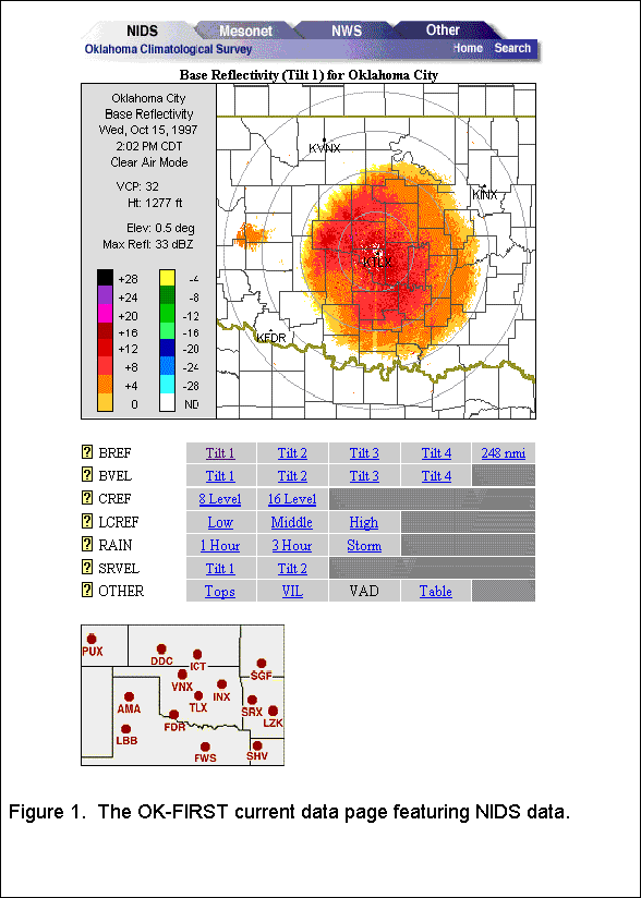
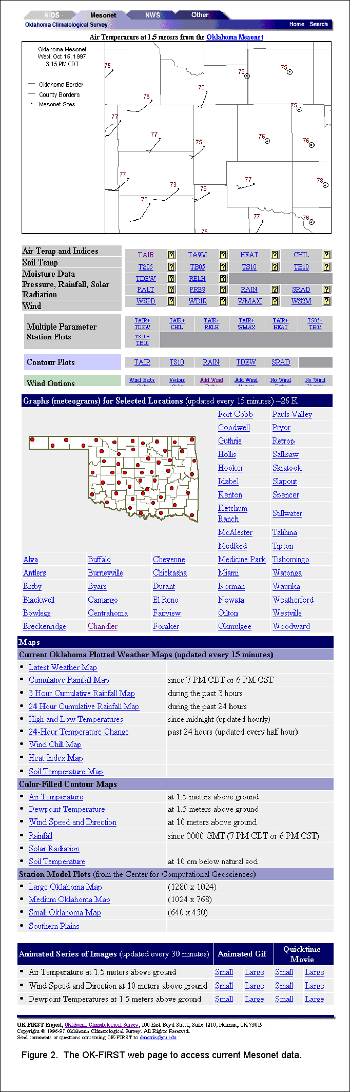
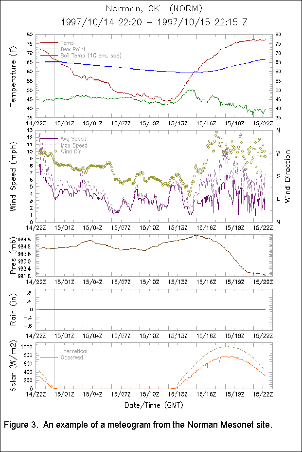
This manuscript will describe the methodology used to design the real-time availability of these data sources using the WWW. Because OK-FIRST is a decision-support system, information other than current weather data is available. The organization and integration of this auxiliary information with the current data also will be described. Finally, suggestions from end-users about ways to improve of this data-sharing system will be presented. One design consideration for the OK-FIRST Web pages was to minimize the user interaction required to request Mesonet and NIDS data while maximizing the user interaction with the data. This concept was facilitated using web-browser “plug-in” software (Wolfinbarger et al. 1998a,b) that visualizes the data on the client machines, greatly reducing server overhead. Otherwise, raw NIDS and Mesonet data would have to be converted to standard image formats (like GIF or JPEG) to be displayed via the Web. In addition, server-side image creation limits the user’s ability to customize and interact with the data. FInally, because the raw Mesonet and NIDS data files tend to be smaller than their corresponding image equivalents, this processing scheme reduces bandwidth consumption. On the Web server, CGI (Command Gateway Interface) software delivers the current weather data to the client machines. This software determines which of the ingested products is the most recent and delivers the data upon receiving a request from the client machines. Form-based menus to request data were avoided in the CGI software to reduce the steps required for users to download data. The Web pages also are designed to request and deliver Mesonet and NIDS files every 15 and 6 minutes, respectively, to help ensure that users are making decisions based upon the most current information. The “current data” section of the OK-FIRST web site is divided into four areas: NIDS, Mesonet, NWS Products, and Other Data. Users can request data in either “one-screen” or “two-screen” modes. One-screen mode presents a larger image, but the two-screen mode (using web-browser “frames”) allows side-by-side comparison of any combination of the available data sets. The user can switch easily switch from section to section by clicking on file tabs at the top of the page (Fig. 1). An “image map” of the available radar sites is presented below the table of NIDS products. When the user clicks on a dot, the current product from the desired radar will be requested and delivered to the user. For example, if the user clicked on “LBB” in the map (Fig. 1), the 0.5 degree base reflectivity product from the Lubbock, TX radar (KLBB) would be displayed. Thus, the user can easily obtain any of the 300+ available NIDS products without having to select the products from a complex menu system. An interactive weather map displays Mesonet data at the top of the page. The interactivity is accomplished using the WxScope plug-in (Wolfinbarger et al. 1998b). The Web server transmits map document files to the plug-in. These files contain settings (e.g., Mesonet parameters, colors, units, background maps, etc.) customized by the Web page designer. Hence, a great deal of flexibility can be achieved, but the risk potentially is in making the Web page overly complex. Below the map is a table of available parameters. If the user should choose the “TDEW” link on the third row of the table, then the plug-in would display the dew point temperature computed from Mesonet observations. Contour plots of air temperature, dew point, soil temperature, rainfall accumulation, and solar radiation are available, but a pending upgrade of the plug-in software will allow contouring of additional parameters. Wind barbs or wind vectors can be added to depict the wind field. Additional options for viewing Mesonet data are available below the interactive map. For example, meteograms (e.g., Fig. 3) are prepared for about half of the Mesonet sites. These meteograms display a time series of Mesonet observations for a single site
for the previous 24 hours. The meteograms are updated every fifteen minutes. Several non-interactive map products are listed in the table beneath the meteograms. These products include maximum and minimum temp-eratures, heat indices and wind chills, and rainfall totals. Other products include color-filled contour, or gradient, maps of six basic Mesonet products. Finally, animations of color-filled maps of several parameters over the past three hours are available.
2. CURRENT DATA ACCESS
OK-FIRST utilizes a UNIX-based web server, which is networked both to a satellite-based ingest system for NIDS data and to the Oklahoma Mesonet ingest system. Current data are always available to clients requesting products via the Web.
2.1 NIDS Data
OK-FIRST participants can obtain any of the standard NIDS products from the fourteen radars that provide weather surveillance over Oklahoma The NIDS image is displayed (Fig. 1) using the NIDS Viewer plug-in (Wolfinbarger et al. 1998a), which allows the user to zoom in and scroll around inside the radar scope. A table of available NIDS products is provided below the plug-in. When the user clicks on a link in the table, the CGI software will send the requested product from the current radar to the user’s web page. For example, in Figure 1, if the user clicked on the “Low” link in the table, the current product of layer composite reflectivity (LCREF) between the surface and 24,000 feet from the Oklahoma City (KTLX) radar would be requested.
2.2 Mesonet Data
Mesonet data can be displayed in more ways
than radar data. Hence, OK-FIRST’s “current data” page for Mesonet data (Fig. 2) is more complex than the NIDS page. Yet, a consistent presentation is maintained between how a user accesses Mesonet and NIDS data.
2.3 NWS and Other Data
The OK-FIRST Web site provides access to text products (watches, warnings, forecasts, and guidance) from the NWS. Currently, this access is provided through links to appropriate NWS servers. The OK-FIRST staff is working toward creating a local database of NWS text data to improve the interface to these data. In addition, accessing these data directly from the OK-FIRST server means that OK-FIRST participants will not have to compete with the large number of nationwide users who access the NWS servers on a daily basis. Several NWS offices already are creating graphical products. OK-FIRST is disseminating those products to Oklahoma public safety users. For example, the Arkansas-Red River Basin River Forecast Center in Tulsa provides many hydrological products (e.g., mosaics of precipitation accumulation for periods up to a month, hydrographs, flash and river flood guidance) on their Web server. OK-FIRST provides links to those products. The OK-FIRST web server provides links to satellite data, radar mosaics from commercial web sites, and sounding and wind profiler data for the Southern Plains. Other available data sources include model output statistics (MOS) that have been reformatted (e.g., English units and local time) to ease interpretation by lay people. OK-FIRST also provides access to some of the most advanced fire weather information available. Personnel at Oklahoma State University, in conjunction with the U.S. Forest Service, developed a new fire danger model for Oklahoma; it is based upon satellite data to estimate the availability of natural fuels to burn plus real-time Mesonet data. This model, which runs five times daily, produces specific indices of fire intensity, fire spread, and energy release. A drought index also is calculated once per day. The Oklahoma state forest service issues Red Flag Fire Alerts based, in part, upon this Oklahoma Fire Danger Model (Carlson and Engle 1998; Carlson et al. 1998). OK-FIRST provides a link to these alerts as well.
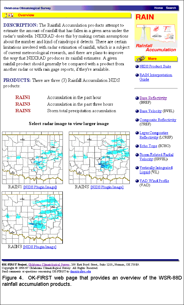
3. AUXILIARY INFORMATION To address this concern, data interpretation aids and product descriptions are on-line. These materials are integrated with the current data pages for ease of access. For example, if the user clicks on the question mark icon that is located to the left of “RAIN” on the NIDS page (Fig. 1), an overview of the WSR-88D rainfall accumulation products (one-hour, three-hour, and storm-totals) is presented (Fig. 4). Additional static information is available through OK-FIRST. When participants attend the workshops, they work through several laboratory exercises to practice interpreting actual weather products. These laboratory exercises are accessible online when the participants return to their local communities. In addition, OCS has created an on-line weather glossary to support its outreach programs. This extensive glossary was enhanced with terms particularly relavent to OK-FIRST participants.
With the host of current weather information available via OK-FIRST, training and end-user support is of supreme importance. One goal of the project is to reduce misapplication of the data. Participants must attend two workshops (3 days of instruction on computer use and a week on data interpretation) plus refresher courses. Yet, this amount of instruction is not sufficient to adequately prepare the participants to use the data and to better understand the products issued by the NWS.
4. FEEDBACK FROM OK-FIRST PARTICIPANTS
Most of the user feedback has been extremely positive. One participant even said that “OK-FIRST was the best tool for emergency managers to come along in a long time”. Another user said he was able to use OK-FIRST to identify a mesocyclone correctly and anticipate an NWS warning for a storm. Yet another emergency manager used the system to direct storm spotters away from hail while still monitoring the storm for rotation. The program’s participants also have suggested improvements to the data pages and software. When they first saw the NIDS Web page, they immediately asked, “Does it animate?” In addition, they have requested additional geographic overlays for the maps and the ability for the data pages to be customized by region. For example, a participant in northeast Oklahoma might rather have the Tulsa radar to be the default radar rather than the Oklahoma City radar. OCS and OK-FIRST staff are constructing strategies to address the animation and other concerns. A planned software upgrade in early 1998 will allow contouring of many more Mesonet parameters than are now available. National and regional mosaics of WSR-88D data and interactive time series graphs of Mesonet data will also be displayable at that time. While a significant amount of information is available through the OK-FIRST Web site (http://okfirst.mesonet.org), we believe the organization of the site Web provides seamless integration of training materials, interpretation aids, and current data products. The “current data” pages provide public safety officials with easy “one-stop shopping” for much of the environmental information they need to be prepared for and to make informed decisions about emergency situations. Feedback from the users thus far has been extremely positive. Many inquiries to the project staff from external parties have resulted from participants demonstrating the system to others who then want to participate. One participant showed the system to his city council members one week after gaining access to the system. Their reaction was that OK-FIRST was the weather monitoring system they expected to see in an Emergency Operations Center. But, for this emergency manager, a dream had just become reality.
5. SUMMARY
The Oklahoma Climatological Survey has implemented a Web-based decision-support system for public safety officials in Oklahoma. The project, known as OK-FIRST, provides current weather data from the Oklahoma Mesonetwork, fourteen NEXRAD radars, and traditional and new products from the modernizing National Weather Service. Data from other relevant agencies is also provided. OK-FIRST has 44 participants (as of January 1988) with additional classes planned for the near future.
6. ACKNOWLEDGEMENTS
The following individuals have contributed their expertise to OK-FIRST: Derek Arndt, Stdrovia Blackburn, Jared Bostic, Amy Cameron, J.D. Carlson, Ken Crawford, Christopher Duvall, Justin Greenfield, Tim Hughes, Howard Johnson, Sridhar Kulasekharan, Cerry Leffler, Billy McPherson, Renee McPherson, Putnam Reiter, Glen Romine, Mark Shafer, Troy Simonsen, Brad Stanley, Mike Wolfinbarger, and Robb Young. This publication was made possible in part by a grant from the Telecommunications and Informatin Infrastructure Assistance Program, National Telecommunications and Information Administrations, U.S. Department of Commerce. Cooperating agencies include the National Weather Service (Norman and Tulsa) and the Institute for Public Affairs at OU. Matching funds are provided by OU, Unisys Weather Information Services, the Oklahoma State Regents for Higher Education, and the Oklahoma Department of Public Safety.
7. REFERENCES
Brock, F.V., K.C. Crawford, R.L. Elliott, G.W. Cuperus, S.J. Stadler, H.L. Johnson, and M.D. Eilts, 1995: The Oklahoma Mesonet: a technical overview. J. Atmos. and Oceanic Tech., 12: 5-19.
Carlson, J.D. and D.M. Engle, 1998: Recent developments in the Oklahoma Fire Danger Model, a mesoscale fire danger rating system for Oklahoma. Preprints, 2nd Symposium on Fire and Forest Meteor., Amer. Meteor. Soc., in press.
Carlson, J.D., D.M. Engle, J.R. Greenfield, and D.S. Arndt, 1998: Development and dissemination of near-real-time weather-based tools for fire management in Oklahoma. Preprints, 2nd Symposium on Fire and Forest Meteor., Amer. Meteor. Soc., in press.
Crawford, K.C., D.A. Morris, R.A. McPherson, H.L. Johnson, M.A. Shafer, J.M. Wolfinbarger, and T.W. Hughes, 1998: OK-FIRST: A decision-support system for public-safety agencies. Preprints, 14th Int’l Conf. on IIPS for Meteor. Ocean., and Hydro., Amer. Meteor. Soc., in press.
Klazura, G.E., and D.A. Imy: 1993: A description of the initial set of analysys products available from the NEXRAD WSR-88D system. Bull Amer. Meteor. Soc., 74, 1293-1311.
McPherson, R.A., and W. G. McPherson Jr., 1993: Tools for visualizing Oklahoma Mesonet data. Preprints, 17th Conf. on Severe Local Storms. Amer. Meteor. Soc.
Morris, D.A., 1994: Interactive display of Oklahoma Mesonet data for public service agencies. Preprints, 10th Int’l Conf. on IIPS for Meteor. Ocean., and Hydro., Amer. Meteor. Soc.
Wolfinbarger J.M., R.A. Young, and T.B. Stanley, 1998a: Interactive software for viewing NEXRAD level 3 data on the World Wide Web. Preprints, 14th Int’l Conf. on IIPS for Meteor. Ocean., and Hydro., Amer. Meteor. Soc., in press.
Wolfinbarger J.M., R.A. Young, and T.B. Stanley, 1998b: Delivering real-time interactive data from the Oklahoma Mesonet via the World Wide Web. Preprints, 14th Int’l Conf. on IIPS for Meteor. Ocean., and Hydro., Amer. Meteor. Soc., in press.