![]()
|
of Winter 2005-06 Answer to Question 8 |
|
8. It's 1:30 pm ... Several fires have been reported!
- Based on what you know from the forecasts and the fire danger model data, what advice would you give your fire personnel?
- Your mayor asks you to tell him how many fires there are, and he wants an answer in five minutes.

Answer.
- The advice you'd give your fire service will probably vary depending on the typ of shop you run (you might be the fire service!). But, your advice would probably include something about flame lengths around 10 feet tall and fires moving from west to east ... for now. Maybe you'd tell them that you are keeping an eye on a gradual wind shift that is approaching from the north.
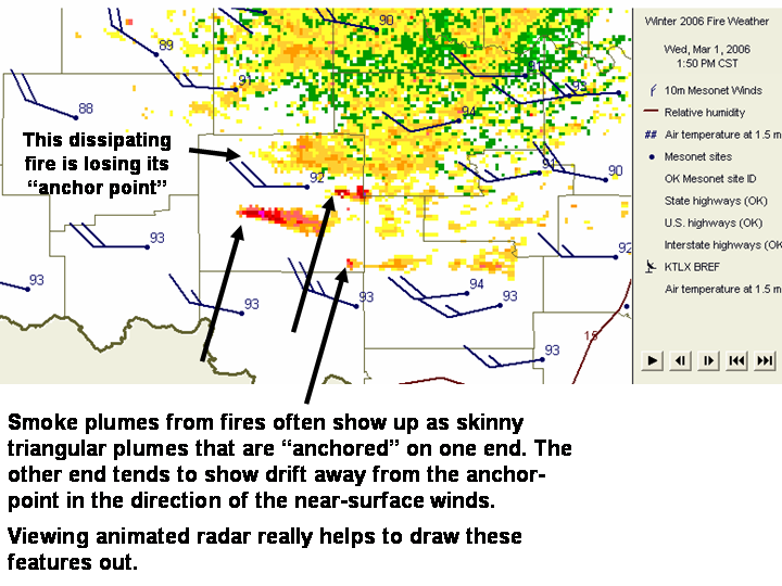
- Radar seems to indicate four smoke plumes in Stephens County over the course of the animation:
- Two flare up early in the loop (one in extreme southeast Stephens County, the other in the northwest corner).
- A third, near the center of the county, appears midway through the loop.
- A fourth, appears in east-central reaches of the county near the end of the loop.
- Beware: Radar is an imperfect tool on a good day! Don't rely on it to see all smoke plumes, especially in precip mode, and far from the radar unit.
The Bottom Line:
-
A large complex of fires is now burning rapidly across the county.
OK-FIRST Project, Oklahoma Climatological Survey, 100 East Boyd, Suite 1210, Norman, OK 73019
Copyright © 1996-2005 Oklahoma Climatological Survey. All Rights Reserved.
Send comments or questions concerning OK-FIRST to okfirst@mesonet.org.