|
|
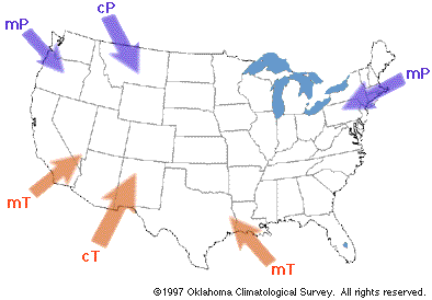
Air Masses That Affect the Continental U.S.
|
- Air masses are relatively large bodies of air that
are fairly horizontally uniform in characteristics. They
have relatively uniform temperature and moisture content;
the region separating two different air masses is called
a front.
Air masses form in "source
regions" where there is little topography and relatively
stagnant winds near the surface. The air mass takes on
the properties of the surface of the source region (e.g.,
dry, hot, moist, etc.). It takes several days for an air
mass to "form", so they generally form in areas of high
pressure (light winds).
- Five air masses affect the United States during the
course of a typical year: continental polar, continental
arctic, continental tropical, maritime polar, and
maritime tropical.
- Continental air masses are characterized by dry
air near the surface while maritime air masses are
moist.
- Polar air masses are characterized by cold air
near the surface while tropical air masses are warm or
hot. Arctic air masses are extremely cold.
- Continental polar (cP) or continental arctic (cA) air
masses are cold, dry, and stable.
These air masses originate over
northern Canada and Alaska as a result of radiational
cooling. They move southward, east of Rockies into the
Plains, then eastward. Continental polar or continental
arctic air masses are marked by surface high pressure,
cold temperatures, and low dew points.
- Maritime polar (mP) air masses are cool, moist, and
unstable.
Some maritime polar air masses
originate as continental polar air masses over Asia and
move westward over the Pacific, collecting warmth and
moisture from the ocean. Some mP air masses originate
from the North Atlantic and move southwestward toward the
Northeast States. The latter air mass generally is colder
and drier than the mP off of the Pacific.
- Maritime tropical (mT) air masses are warm, moist,
and usually unstable.
Some maritime tropical air
masses originate in the subtropical Pacific Ocean, where
it is warm and air must travel a long distance over
water. These rarely extend north or east of southern
California. Some maritime tropical air masses originate
over the Gulf of Mexico and Caribbean Sea. They can be
associated with fog and low clouds as they moves
northward. In the spring and summer, this air mass
accounts for the thunderstorms in the Great Plains and
elsewhere.
- Continental tropical (cT) air masses are hot, dry,
unstable at low levels and generally stable aloft
(upper-level ridge)
Continental tropical air masses
originate in northern Mexico. They are characterized by
clear skies and negligible rainfall. If one moves into
the Great Plains and stagnates, a severe drought can
result.
- Air masses can be modified significantly as they pass
over regions with different characteristics. When air
masses are modified, they are renamed according to their
new characteristics.
Topography can play a crucial
role in the modification of air masses. For example, the
Rocky Mountains cause flow from the west to be lifted
over the mountains. The originally mP air loses its
moisture as it precipitates, leaving dry air to move
eastward. Hence, mP air becomes cP air after it is forced
over the Rockies.
- Most large-scale weather events occur at the boundary
of two or more air masses.
|
