|
|
Weather Fronts
|
|
|
|
|
|
|
Principle
|
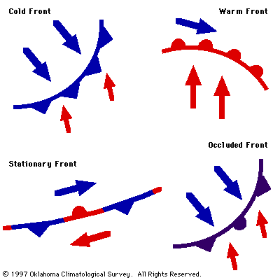
Fronts are zones of transition between
two different air masses. The zone may be 20 miles across or
it may be 100 miles across, but from one side of a front to
the other, one clearly would sense that the properties of an
air mass had changed significantly (e.g., contrasts in
temperature and dew point, wind direction, cloud cover, and
on-going weather). The frontal zone represents the leading
edge of a wedge of cold/cool air. If the wedge is moving
into an area of warmer air, the front is called a cold
front. If the wedge is retreating and warmer air is moving
into an area previously occupied by cool air, the front is
termed a warm front.
|
|
|
|
|
|
|
Figure 1 - Types of Fronts
|
|
|
|
|
|
Definition
|
- Fronts are boundaries between air masses of different
temperatures.
Fronts are actually zones of
transition, but sometimes the transition zone, called a
frontal zone, can be quite sharp.
- The type of front depends on both the direction in
which the air mass is moving and the characteristics of
the air mass.
There are four types of fronts
that will be described below: cold front, warm front,
stationary front, and occluded front.
- To locate a front on a surface map, look for the
following:
- sharp temperature changes over relatively short
distances,
- changes in the moisture content of the air (dew
point),
- shifts in wind direction,
- low pressure troughs and pressure changes, and
- clouds and precipitation patterns.
Not all of these patterns may be
obvious or even occur, but these are some signs.
|
|
|
|
|
|
|
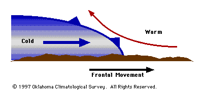
Figure 2 - Side View of a Typical Cold Front
|
|
|
|
|
|
Cold Fronts
|
- Cold front- a front in which cold air is replacing
warm air at the surface.
- Some of the characteristics of cold fronts include
the following:
- The slope of a typical cold front is 1:100
(vertical to horizontal).
- Cold fronts tend to move faster than all other
types of fronts.
- Cold fronts tend to be associated with the most
violent weather among all types of fronts.
- Cold fronts tend to move the farthest while
maintaining their intensity.
- Cold fronts tend to be associated with cirrus well
ahead of the front, strong thunderstorms along and
ahead of the front, and a broad area of clouds
immediately behind the front (although fast moving
fronts may be mostly clear behind the front).
- Cold fronts can be associated with squall lines (a
line of strong thunderstorms parallel to and ahead of
the front).
- In winter, cold fronts move into Oklahoma mainly from
the Canadian prairies but sometimes from the Arctic
Circle or the eastern Pacific.
- Cold fronts almost always are easier to locate on a
weather map than are warm fronts, primarily because of
the strength of the high pressure system to the north and
west of the cold front compared to that north of a warm
front.
- Cold fronts usually bring cooler weather, clearing
skies, and a sharp change in wind direction.
|
|
|
|
|
|
|
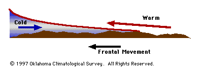
Figure 3 - Side View of a Typical Warm Front
|
|
|
|
|
|
Warm Fronts
|
- Warm front- a front in which warm air replaces cooler
air at the surface.
- Some of the characteristics of warm fronts include
the following:
- The slope of a typical warm front is 1:200 (more
gentle than cold fronts).
- Warm fronts tend to move slowly.
- Warm fronts are typically less violent than cold
fronts.
- Although they can trigger thunderstorms, warm
fronts are more likely to be associated with large
regions of gentle ascent (stratiform clouds and light
to moderate continuous rain).
- Warm fronts are usually preceded by cirrus first
(1000 km ahead), then altostratus or altocumulus (500
km ahead), then stratus and possibly fog.
- Behind the warm front, skies are relatively clear
(but change gradually).
- Warm fronts are associated with a frontal
inversion (warm air overrunning cooler air).
- If a warm front exists on a weather map, it will be
northeast of the cold front and often, to the east of a
surface low pressure area.
- Clouds and precipitation are quite prevalent to the
north of the warm front.
This results from the fact that
low-level southerly winds in the "warm sector" of the
cyclone rise up and over the cooler, more dense air at
the surface located north of the warm front. The lifting
leads to saturation, cloud formation, and, ultimately, to
some form of precipitation.
- In Oklahoma, warm fronts are rare in the winter and
non-existent in the summer.
|
|
|
|
|
|
|
Stationary Fronts
|
- Stationary front- a front that does not move or
barely moves.
- Stationary fronts behave like warm fronts, but are
more quiescent.
- Many times the winds on both sides of a stationary
front are parallel to the front.
- Typically stationary fronts form when polar air
masses are modified significantly so as to lose their
character (e.g., cold fronts which stall).
|
|
|
|
|
|
|
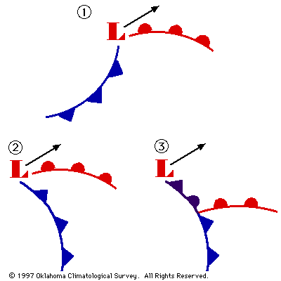
Figure 4 - Development of an Occluded Front
|
|
|
|
|
|
Occluded Fronts
|
|
|
|
|
|
|
|
End
|
|