|
|
||||

| NEXRAD Radar Available to OK-FIRST Participants | ||
| A suite of products called NIDS (NEXRAD Information Dissemination Service) products is available for each of the following sites. In addition, Unisys creates mosaic products which combine information from all of the radars into a single graphic. These value-added products are also available. | ||
| KAMA | KDDC | |
|
Amarillo, TX National Weather Service radar Latitude: 35.23 degrees North Longitude: 101.71 degrees West |
Dodge City, KS National Weather Service radar Latitude: 37.76 degrees North Longitude: 99.97 degrees West |
|
| KDYX | KFDR | |
|
Abilene, TX (Dyess Air Force Base) U.S. Department of Defense radar Latitude: 32.53 degrees North Longitude: 99.25 degrees West |
Frederick, OK (Altus Air Force Base) U.S. Department of Defense radar Latitude: 34.36 degrees North Longitude: 98.98 degrees West |
|
| KFWS | KICT | |
|
Dallas/Ft. Worth, TX National Weather Service radar Latitude: 32.57 degrees North Longitude: 97.30 degrees West |
Wichita, KS National Weather Service radar Latitude: 37.65 degrees North Longitude: 97.44 degrees West |
|
| KINX | KLZK | |
|
Tulsa, OK (Inola) National Weather Service radar Latitude: 36.17 degrees North Longitude: 95.56 degrees West |
Lubbock, TX National Weather Service radar Latitude: 33.65 degrees North Longitude: 101.81 degrees West |
|
| KLZK | KPUX | |
|
Little Rock, AR National Weather Service radar Latitude: 34.84 degrees North Longitude: 92.26 degrees West |
Pueblo, CO National Weather Service radar Latitude: 38.46 degrees North Longitude: 104.18 degrees West |
|
| KSGF | KSHV | |
|
Springfield, MO National Weather Service radar Latitude: 37.24 degrees North Longitude: 93.24 degrees West |
Shreveport, LA National Weather Service radar Latitude: 32.45 degrees North Longitude: 93.84 degrees West |
|
| KSRX | KTLX | |
|
Fort Smith, AR National Weather Service radar Latitude: 35.29 degrees North Longitude: 94.36 degrees West |
Oklahoma City, OK (Twin Lakes) National Weather Service radar Latitude: 35.33 degrees North Longitude: 97.28 degrees West |
|
| KVNX | ||
|
Enid, OK (Vance Air Force Base) U.S. Department of Defense radar Latitude: 36.74 degrees North Longitude: 98.13 degrees West |
||
| Map of NEXRAD Radars Available to OK-FIRST | 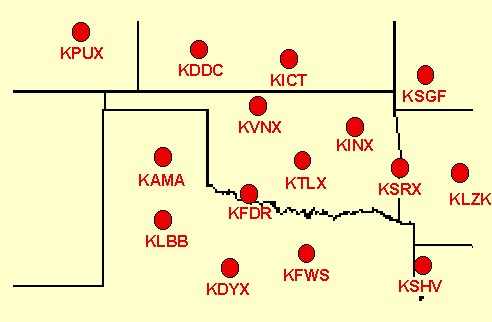 |
|
OK-FIRST Project,
Oklahoma Climatological Survey,
100 East Boyd Street, Suite 1210,
Norman, OK 73019.
Copyright © 1996-2000 Oklahoma Climatological Survey. All Rights Reserved. Send comments or questions concerning OK-FIRST to dmorris@ou.edu |