![]()
|
Answer to Question 9 |
|
|
Question 9. Describe the evolution of the features noted in question 1 over the duration of this event. Can
these Mesonet features be related to features in the radar data?
|
|
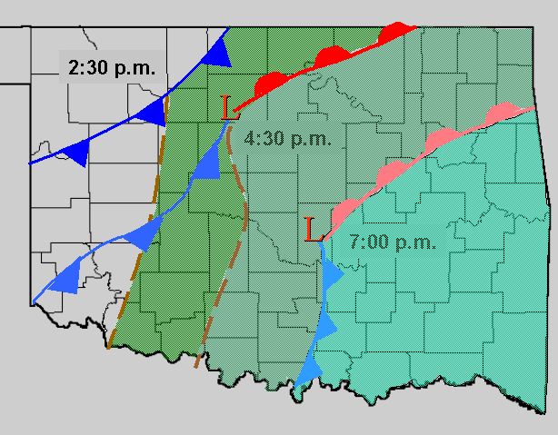
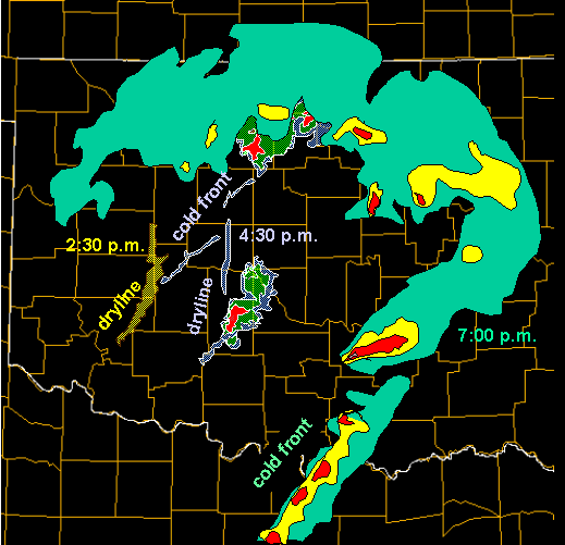
Answer. In the Mesonet data, the southeast progression of the surface low and its accompanying cold front, dryline, and warm front were easily detected. The Mesonet also illustrated the southeast progression of the moist sector, which became more moist in time (50°F dewpoints at 2:30 and 55-60°F dewpoints at 4:30 and 7:00 p.m). A thin line on the radar (in clear-air mode) at 2:30 was aligned with the corresponding dryline in the Mesonet data. Two thin lines on the radar at 4:30 represented the cold front (northeast to southwest alignment) and the dryline (north to south alignment). Also, at 4:30, the radar detected two supercell thunderstormsr. By 7:00 p.m, the southern supercell split into two storms; the right moving storm from the southern cell moved into Pontotoc county. More stratiform precipitation developed along the warm front at 7:00 p.m., and a north to south squall line formed in southern Oklahoma where the cold front overtook the dryline. |
|
|