![]()
|
|
|
of June 27, 1995 |
 |
| Event Summary
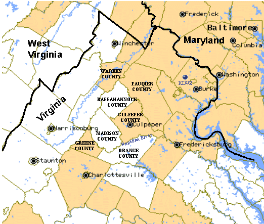
Heavy rain, falling on near-saturated soil, caused catastrophic flooding and flash flooding in north central Virginia, leaving three people dead, at least 20 injured, and $80 million in private and public property damage and nearly $100 million in agricultural damage. The most severe flooding occurred in Madison County, where rainfall likely exceeded 20 inches in a 12-hour period at higher elevations. One cooperative observer recorded 10 inches in two hours! Other substantial flooding was reported in northern Greene, northwest Rappahannock, northwest Culpeper, Orange, and Warren Counties during the day on the 27th. Rainfall at these locations likely exceeded 10 inches. River flooding was pronounced along the Rapidan and Rappahannock basins. With the ground nearly saturated, heavy rains in Madison and Orange and Warren Counties became direct runoff and flowed into the Rapidan. Flooding along the Rapidan along the Greene/Madison County line was deemed to be a 500-year event. |
Objectives
|
|
|
|
| Conclusions
1. Major highway arteries were closed for days after the floods due to washed-out bridges or damaged road surfaces and supports. Federal Highway 29, a major thoroughfare between Washington, DC and Southwest Virginia, was cut off when the bridge linking Madison and Greene Counties was washed away. 2. The larger of two storm systems passed through the Rapidan river basin between 0500 - 1000 UTC (1:00 a.m. to 6:00 a.m. EDT). A smaller storm system, which had horizontal dimensions less than 20 km by 20 km, moved slowly through the upper Rapidan River basin from 1200 - 2000 UTC (8:00 a.m. 4:00 p.m. EDT) and produced the record flood peak. The operational WSR-88D rainfall products yielded underestimates of storm total rainfall for the Rapidan storm by a factor of approximately 3. Underestimation of extreme rainfall has been recognized as a problem for the radar, espeically for storms dominated by warm rain processes in which the highest reflectivity values occur in the lowest portion of the cloud. 3. Storm motion played a key role in the production of heavy rainfall for the Rapidan storm. The apparent storm motion was from the northeast to the southwest and generally followed the peak of the Blue Ridge. It is important to note that the direction of storm motion did not correspond with wind direction at any level. This is because net storm motion resulted from propagation rather than advection (i.e., the location of growth of new components of the storm dictated the apparent storm motion). |
