![]()
|
of August 13-15, 2005 Answer to Question 8 |
|
8. It's 7:00 pm on the 14th. Examine the Mesonet surface conditions and the 500 mb chart.
- From what direction are the 500-mb winds blowing in the region?
- What are the 500-mb wind speeds?
- How is the surface front aligned, according to Mesonet data?
- Where would you expect storms to initiate, and in what general direction would they travel?
- Is there sufficient moisture to sustain heavy precipitation?
Answer.
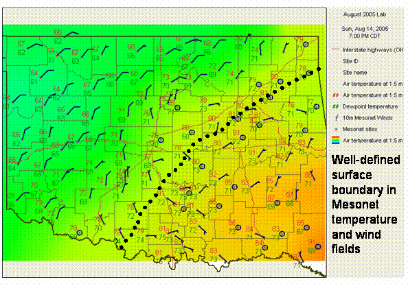
- The temperature and wind fields on the Oklahoma Mesonet very clearly place the front on a Waurika to Shawnee to Tulsa to Jay curve. In other words, it is still aligned southwest-to-northeast very near where it was on the previous day.
- There is no Oklahoma observation at 500 mb, but based on neighboring observations, it is safe to assume that the 500 mb winds are blowing quite weakly from the southwest.
- The 500 mb winds are again aligned generally along the stationary front
- All else being equal, storms will initiate where surface convergence and lift is highest. The stationary front will provide the best lifting mechanism and initiation point. If storms fire on the front, they will likely travel along the front.
- Based on surface dewpoints and the moisture evident in the 850 mb map, there is more than enough moisture to sustain deep, long-lasting convection and heavy precipitation.
The Bottom Line:
-
This set-up is ripe for heavy precipitation: deep low-level moisture, weak upper-level flow, that is generally aligned with a slow-moving surface boundary.
.