![]()
|
of January 3-5, 2005 Answer to Question 10 |
|
10. At 6:00 pm Tuesday evening new soundings were released. Examine the radiosondes (soundings) from Norman and Dodge City.
- What type of precipitation do each of these soundings suggest? Are there discrepancies between the locations?
- What kind of precip would you expect between Dodge City and Norman? What datasets would help you further?
- Does the upper-air critical-thickness plot agree with your assessment?
- Based on the critical thickness maps, what kind of precipitation would you expect in Alva? In Enid?

Answer.
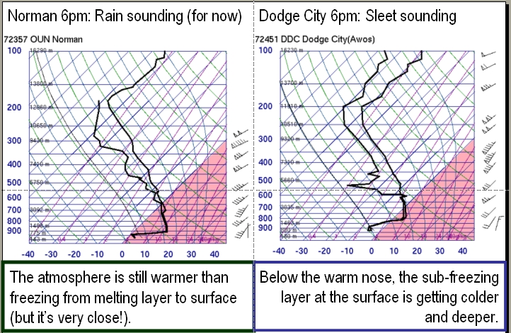
- The Norman sounding again suggests rain, as the warm nose extends all the way to the surface. The Dodge City warm nose is pronounced, but there is a fairly deep and fairly cold surface layer, which suggests sleet, or at least a freezing rain-and-sleet mix.
- Taken together, the soundings suggest precipitation tranisitioning from rain to freezing rain to sleet as one goes from Norman to Dodge City.
- The critical thickness plots place Norman well south of the critical thickness contours, supporting the "rain" assessment there. Dodge City is south of three of the contours and north of one, which neither supports nor denies the "sleet" assessment.
- Based on the critical thickness maps, precipitation is definitely not snow in Alva and Enid. Freezing rain is most likely.
The Bottom Line:
-
Critical thickness plots and soundings offer a good "first guess" at likely precip type.
OK-FIRST Project, Oklahoma Climatological Survey, 100 East Boyd, Suite 1210, Norman, OK 73019
Copyright © 1996-2005 Oklahoma Climatological Survey. All Rights Reserved.
Send comments or questions concerning OK-FIRST to okfirst@mesonet.org.