|
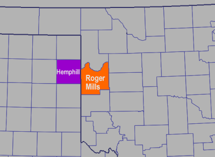
1. Look at these four forecasts from local NWS forecast offices for the bordering counties of Hemphill (TX) and Roger Mills (OK). Forecasts valid for Tuesday, Jan 4 are highlighted in bold-blue. Forecasts valid for Wednesday, Jan 5 are highlighted in bold-green.
- For a given time, what differences do you notice between the two counties?
- For a given county, what differences do you notice from one forecast to the next?
- Why do you think two neighboring counties can get substantially different forecasts?
- Why do you think each county's forecast changes noticably from one forecast to the next?
Answer
|
|
2. Now, scan through the forecast discussions that accompanied each of these forecasts. Zone/County forecasts are usually quite "narrow", even if the forecaster is wrestling with a wide range of issues. Various threats are empahisized in bold. Selected statements of uncertainty are highlighted in italics.
- Are the forecasters from each office wrestling with similar concerns, even if their "official" forecasts were different at times?
- What are the weather threats to consider for Tuesday into Wednesday?
- What are the causes of uncertainty in the forecast? Why are these important in a winter weather scenario?
- What level of confidence would you assign to each "official" forecast?
- What details are available in the discussions that aren't available in the "official" forecasts?
Answer
|
|
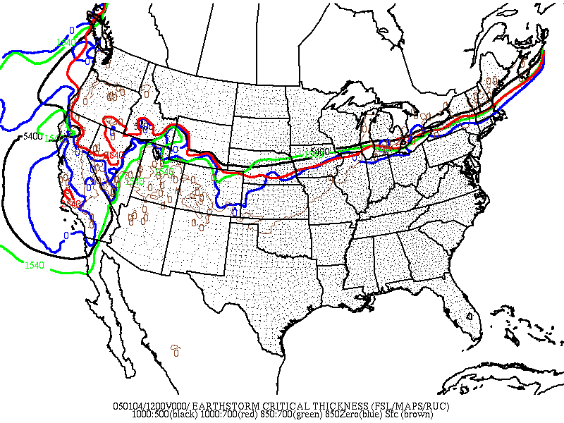
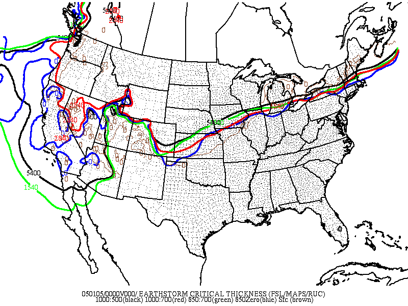
3. Forward to 6:00 am Tuesday morning. Precipitaton is occurring across much of Oklahoma and the Texas panhandle. Examine the OK-FIRST "critical thickness" map for 6:00 am. Based on this critical thickness map:
- In northwestern Oklahoma, what is the probable form of precipitation (snow or non-snow) as it falls from clouds?
- How confident are you in this assessment?
- Does this mean it will definitely reach the surface in this form?
Answer
|
|
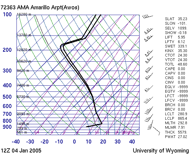
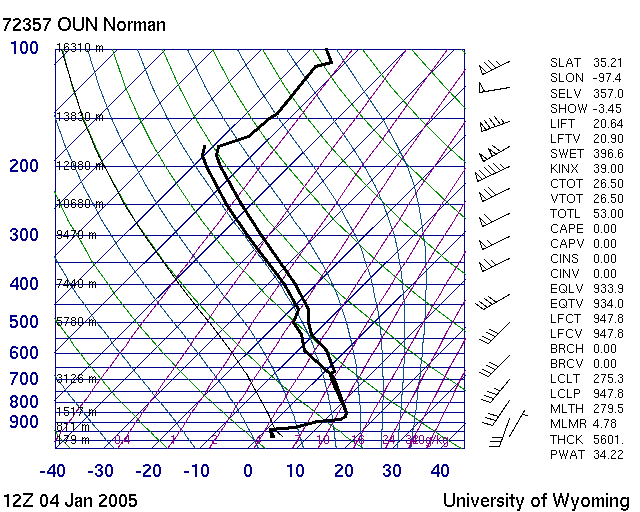
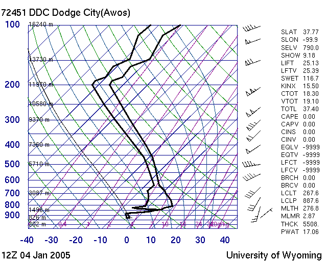
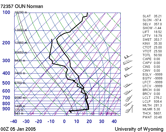
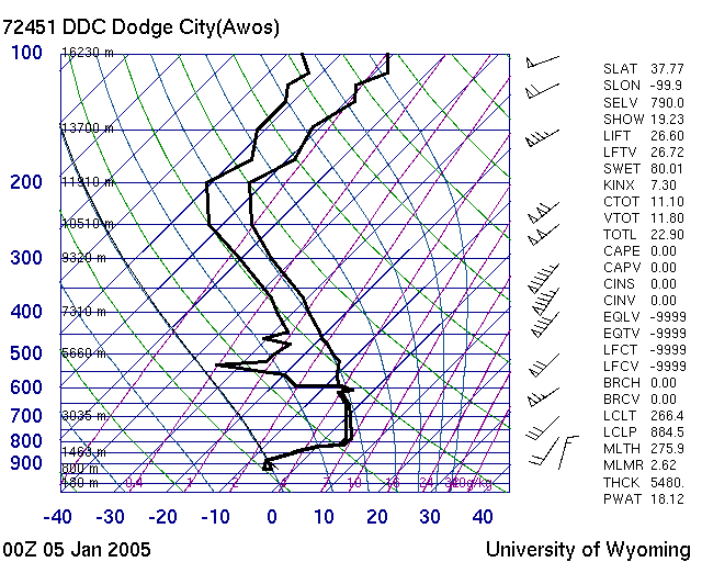
4. One more 6:00 am Tuesday product. Examine the radiosondes (soundings) from Amarillo, Norman, and Dodge City.
- What type of precipitation do each of these soundings suggest?
- Are there any discrepancies between the locations?
- What needs to change, and by how much, in order to change precip type?
- With strong southwesterly winds above 850 mb, do you expect these layers to cool dramatically in the near future?
- What do the surface winds at each location suggest?
Answer
|
|
5. It's still 6:00 am Tuesday morning. Radar indicates precipitation across much of Oklahoma and the Texas panhandle. Examine the WSR-88D base reflectivity
(tilt 1) data from KTLX-Norman, KTLX-Vance AFB, and KAMA-Amarillo (you can toggle each off/on in the legend). Based on this reflectivity data:
- What is the probable form of precipitation (liquid or frozen) as it falls from clouds?
- How confident are you in this assessment?
- Does this mean it will definitely reach the surface in this form?
- What other data would be valuable in identifying precipitation type at the surface?
Answer
|
|
6. Examine a movie from 4:00 am to noon on Tuesday Jan 4th, with BREF1 from Vance AFB (KVNX), Mesonet air temperatures and Mesonet wind observations.
- What precip type is suggested by the radar echoes?
- Where is the freezing line, in relation to the precip observed by the Vance radar?
- What is happening to the Mesonet's wind observations north and west of the freezing line? Why is this?
Answer
|
|
7. Examine the 5:00 pm storm-total rainfall estimates for the Vance-KVNX, Wichita-KICT, and Norman-KTLX radars.
- About how much precipitation has fallen north of the freezing line?
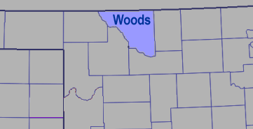
- Focus on Eastern Woods County. Do the three radar estimates agree on storm-total precipitation here? What may be some causes of disagreement?
- Focus on Southeastern Woods County. Do the three radar estimates agree on storm-total precipitation here? What may be some causes of disagreement?
Answer
|
|
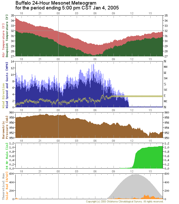
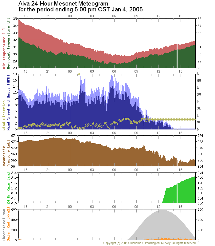
8. Still 5:00 pm Tuesday. Examine the map which shows the 5 cm soil temperatures, under native sod (blue) and under bare soil (red). The Mesonet air temperature freezing line is still in pink. Some recent Local Storm Reports (LSRs) from Norman are given below.
- Based on the soil temperatures, do you think much ice is sticking to the ground in northwestern Oklahoma?
- Focus on the temperature, wind and rainfall panels of the Buffalo and Alva meteograms. What clues do they give you about whether ice is accumulating on the ground? On elevated structures?
Answer
|
|
9. It is now 7:30 pm on Tuesday night. More than half an inch of ice has frozen on limbs, powerlines and elevated structures in much of northwest Oklahoma. Examine the most recent discussion products from the Storm Prediction Center and the Norman WFO.
- Will the ice storm continue in the upcoming hours?
Answer
|
|
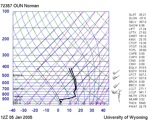
10. At 6:00 pm Tuesday evening new soundings were released. Examine the radiosondes (soundings) from Norman and Dodge City.
- What type of precipitation do each of these soundings suggest? Are there discrepancies between the locations?
- What kind of precip would you expect between Dodge City and Norman? What datasets would help you further?
- Does the upper-air critical-thickness plot agree with your assessment?
- Based on the critical thickness map, what kind of precipitation would you expect in Alva? In Enid?
Answer
|
11. Compare the thickness map from Question 10 to the Mesonet surface temperature map. Focus on the placement of the freezing line at the surface. Both of these products were valid at 6:00 pm
- Do the two products place the freezing line in the same place?
- Which should you believe? Why?
Answer
|
|
12. Examine a movie from 6:00 pm Tuesday through 2:00 am Wednesday, with BREF1 from Vance AFB (KVNX) and BREF1 from Norman (KTLX) (hint: toggle the radars in the legend to see individual features). Mesonet air temperatures and Mesonet wind observations are included.
- What precip type is suggested by the radar echoes?
- Where is the freezing line, in relation to the precip observed by the each radar (KTLX and KVNX)?
- Does the freezing line begin to move during this 8-hour movie?
- What do you notice about the placement and motion of the heaviest precipitation elements? What threats do you think are present in northwest and west-central Oklahoma? What about on the warm side (south and east) of the freezing line?
Answer
|
|
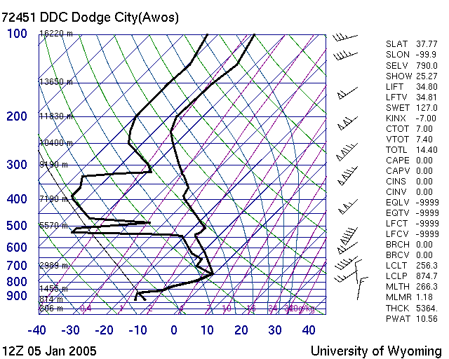
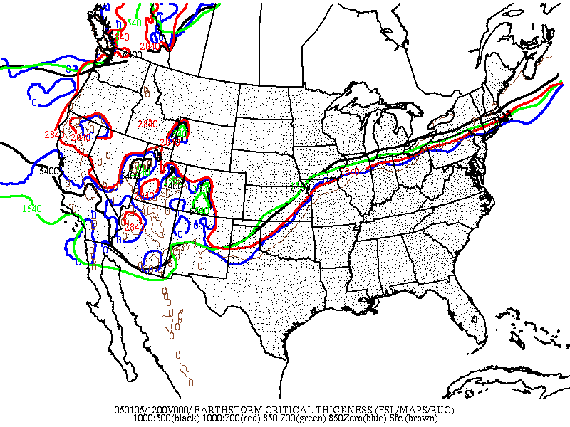
13. Last Question (hooray!!!!). It is now the morning of the 5th. The precipitation has continued strongly throughout the morning. At 6:00 am new soundings were released. Examine the radiosondes (soundings) from Norman and Dodge City.
- What type of precipitation do each of these soundings suggest? Are there discrepancies between the locations?
- What kind of precip would you expect closer to Dodge City? Closer to Norman?
Critical Thickness
Answer
|