![]()
|
of January 3-5, 2005 Answer to Question 3 |
|
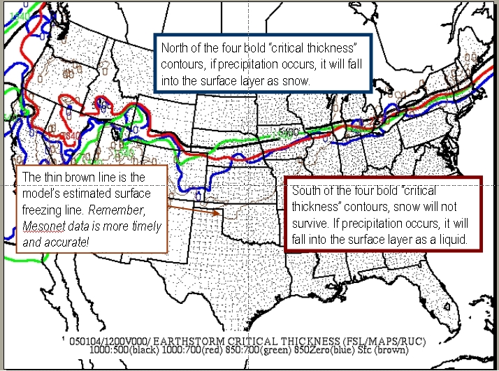
3. Forward to 6:00 am Tuesday morning. Precipitaton is occurring across much of Oklahoma and the Texas panhandle. Examine the OK-FIRST "critical thickness" map for 6:00 am. Based on this critical thickness map:
- In northwestern Oklahoma, what is the probable form of precipitation (snow or non-snow) as it falls from clouds?
- How confident are you in this assessment?
- Does this mean it will definitely reach the surface in this form?

Answer.
The OK-FIRST critical thickness plots show five "spaghetti" lines. The four bold lines (red, black, blue, green) are "critical thickness" values. These contours help determine precipitation type as it falls to near the surface. On the north/cool side of all of the contours, snow survives, so precipitation is falling as snow. On the south/warm side of all of them, snow typically melts. Between the bold contours, the answer is "unknown".
- Because northwestern Oklahoma is well south of all of the thickness contours, a precipitation type of liquid ("not snow") is a fairly confident choice.
- IMPORTANT! Critical thickness contours only estimate snow versus non-snow as it comes out of the clouds. Surface and near-surface temperatures will have the ultimate say over what happens at the ground. The fifth (thin brown) line is the forecast model's estimated position of the surface freezing line.
- Use the thin brown line with caution. As shown in question 2, models are often quite poor at locating the surface freezing line. The Oklahoma Mesonet will give you more accurate and timely surface information.
The Bottom Line:
-
Critical thickness plots can help you assess snow-verus-liquid precip types during the hours leading up to an event, and during the hours between forecast updates.
OK-FIRST Project, Oklahoma Climatological Survey, 100 East Boyd, Suite 1210, Norman, OK 73019
Copyright © 1996-2005 Oklahoma Climatological Survey. All Rights Reserved.
Send comments or questions concerning OK-FIRST to okfirst@mesonet.org.