![]()
|
of January 3-5, 2005 Answer to Question 5 |
|
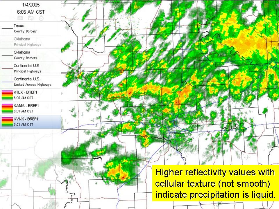
5. 6:00 am Tuesday morning. Radar indicates precipitation across much of Oklahoma and the Texas panhandle. Examine the WSR-88D base reflectivity (tilt 1) data from KTLX-Norman, KTLX-Vance AFB, and KAMA-Amarillo (you can toggle each off/on in the legend). Based on this reflectivity data:
- What is the probable form of precipitation (liquid or frozen) as it falls from clouds?
- How confident are you in this assessment?
- Does this mean it will definitely reach the surface in this form?
- What other data would be valuable in identifying precipitation type at the surface?
Answer.
- The reflectivity patterns from each of the three radar locations have a "mottled", cellular texture characteristic of non-snow precipitation (Snow often has a "brushed" or smooth reflectivity appearance).
- The agreement with the critical thickness and the sounding data helps raise confidence in this assessment.
- However, just because precipitation is falling as a liquid does not mean it will remain a liquid upon or shortly before landing.
- Surface temperatures, like those from the Oklahoma Mesonet, will provide critical detail on the ultimate precipitation type.
The Bottom Line:
- Like critical thicknesses and soundings, radar data can be used to assess snow versus non-snow (rain,sleet) precipitation.
- Like critical thicknesses and soundings, radar data can only provide guidance on what is falling, and cannot tell you about precipitation type on contact.
OK-FIRST Project, Oklahoma Climatological Survey, 100 East Boyd, Suite 1210, Norman, OK 73019
Copyright © 1996-2005 Oklahoma Climatological Survey. All Rights Reserved.
Send comments or questions concerning OK-FIRST to okfirst@mesonet.org.