![]()
|
of January 3-5, 2005 Answer to Question 4 |
|
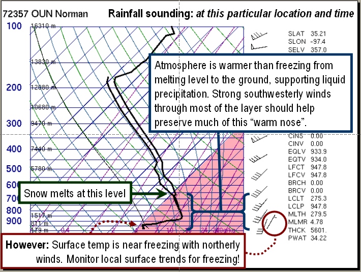
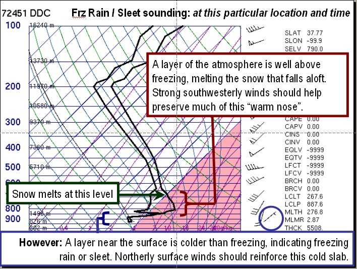
4. One more 6:00 am Tuesday product. Examine the radiosondes (soundings) from Amarillo, Norman and Dodge City.
- What type of precipitation do each of these soundings suggest?
- Are there any discrepancies between the locations?
- What needs to change, and by how much, in order to change precip type?
- With strong southwesterly winds above 850 mb, do you expect these layers to cool dramatically in the near future?
- What do the surface winds at each location suggest?
Answer.
- The Norman and Amarillo soundings suggest liquid precipitation that falls into an above-freezing surface layer.
- The Dodge City sounding has a substantial "warm nose" above the surface that will melt any snow that falls into it. However, it also shows a surface layer that is below freezing. Therefore, at the time of the sounding, precipitation near Dodge City will likely be sleet or freezing rain.
- The surface temperature at Norman is perilously close to freezing, and a drop of just a few degrees will change the expected precipitation type from rain to freezing rain.
- All soundings show strong southwesterly winds through most of the "warm nose". This will likely sustain above-freezing temperatures in those layers.
- Northerly surface winds at Dodge City and Norman suggest cooling in the lowest layers.
The Bottom Line:
- Soundings provide very precise and valuable data for determinng precipitation type.
- Unfortunately, people who use them are forced to fill in the 12 hours and hundreds of miles between soundings.
OK-FIRST Project, Oklahoma Climatological Survey, 100 East Boyd, Suite 1210, Norman, OK 73019
Copyright © 1996-2005 Oklahoma Climatological Survey. All Rights Reserved.
Send comments or questions concerning OK-FIRST to okfirst@mesonet.org.